Hazardous Weather Outlook: Wintry Mix Leading to Possible Heavy Snow Saturday Night
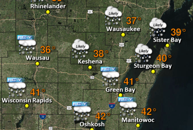
(National Weather Service Green Bay WI) Hazardous travel conditions as a result of a wintry mix of light snow and freezing drizzle are likely to develop over north-central and far northeast Wisconsin beginning by mid morning Thursday (January 9th) and continuing into early evening.
Up to an inch of snow and ice accumulations up to a tenth of an inch are expected across north-central and far northeast Wisconsin. A brief period of freezing precipitation is also expected farther south, mainly between 9 am and noon Thursday.
Strong gusty southeast to south winds may lead to ice shoves on the western shoreline of Green Bay from Marinette to Suamico, and also on the northwest shore of Lake Winnebago.
In addition, gusty onshore winds and 9 to 13 foot waves will likely lead to localized flooding and beach erosion along the Lake Michigan shoreline.
Accumulating snow will be possible at times this weekend, and could lead to hazardous conditions. Light snow will be possible over northeast Wisconsin on Friday night. Then a much stronger system could potentially impact the region Saturday night, particularly over east-central Wisconsin.
This storm will have the potential to produce several inches of snow across mainly eastern portions of Wisconsin. Gusty north to northeast winds may increase the potential for ice shoves and additional lakeshore flooding and erosion.
The exact track, impacts, and snowfall amounts from this system are still uncertain.
For Further Weather Service Updates, Please Click Here.
